Route
Interest
corniche de la Riviera / vieux port de Menton / arrière-pays niçois / Mont Chauve à Aspremont / cathédrale de Vence / corniche de l’Estérel / vieux port de Saint-Raphaël / rocher de Roquebrune / ancienne abbaye du Thoronet / ancien palais des Comtes de Provence de Brignoles / basilique de St-Maximin-la-Sainte-Baume / montagne Sainte-Victoire / cathédrale Saint-Sauveur d’Aix-en-Provence / château de l’Emperi de Salon-de-Provence / chaîne des Alpilles / arène et théâtre romain d’Arles / abbatiale de Saint-Gilles / Petite Camargue / promenade royale du Peyrou à Montpellier
Interruption of the E-path: pending approval
château des Archevêques de Narbonne à Capestang / cathédrale de Narbonne / étang de Bages et de Sigean / fort de Salses à Salses-le-Château
Interruption of the E-path to the Spanish border: in planning
Starting Point
Italian border at Menton
Provisional end Point
Salses-le-Château (Pyrénées-Orientales)
Which cities and towns does the E-path pass through
Menton, Fréjus, Lorgues, Aix-en-Provence, Arles, Montpellier
Interruption of the E-path: pending approval Capestang, Narbonne, Salses-le-Château
Interruption of the E-path to the Spanish border: in planning
Length
582 km
Ground paths of the E-path, marking and responsible for marking
– GR® 653 Voie Aurélienne (fully) : Menton (Alpes-Maritimes) – Arles (Bouches-du-Rhône)
– GR® 653 : Arles (Bouches-du-Rhône) – Montpellier (Hérault)
Interruption of the E-path between Montpellier and Capestang: pending approval
– GR® 78 : Capestang (Hérault) – Mont-Caramel (Hérault-Aude)
– GR® de Pays « Aude romaine et médiévale » : Mont-Caramel (Hérault-Aude) – Narbonne (Aude)
– GR® de Pays « Golfe Antique » : Narbonne (Aude) – Port-la-Nouvelle (Aude)
– GR® de Pays « Ancienne frontière occitano-catalane » : Port-la-Nouvelle (Aude) – Salses-le-Château (Pyrénées-Orientales)
Interruption of the E-path to the Spanish border: in planning
Marking: double white-red line
(except for the GR® de Pays marked with a double yellow-red line)
Responsible for marking: FFRandonnée committees Alpes-Maritimes, Var, Bouches-du-Rhône, Gard, Hérault, Aude et Pyrénées-Orientales.
Publications
Sections of the E-path on FFRandonnée topo-guides, available on the ffrandonnee.fr website
 GR® 653 « Sentier vers Saint-Jacques-de-Compostelle, via Arles (Arles – Toulouse) », ref. 6533
Maps
IGN has several maps that cover the route
Crossing other E-paths
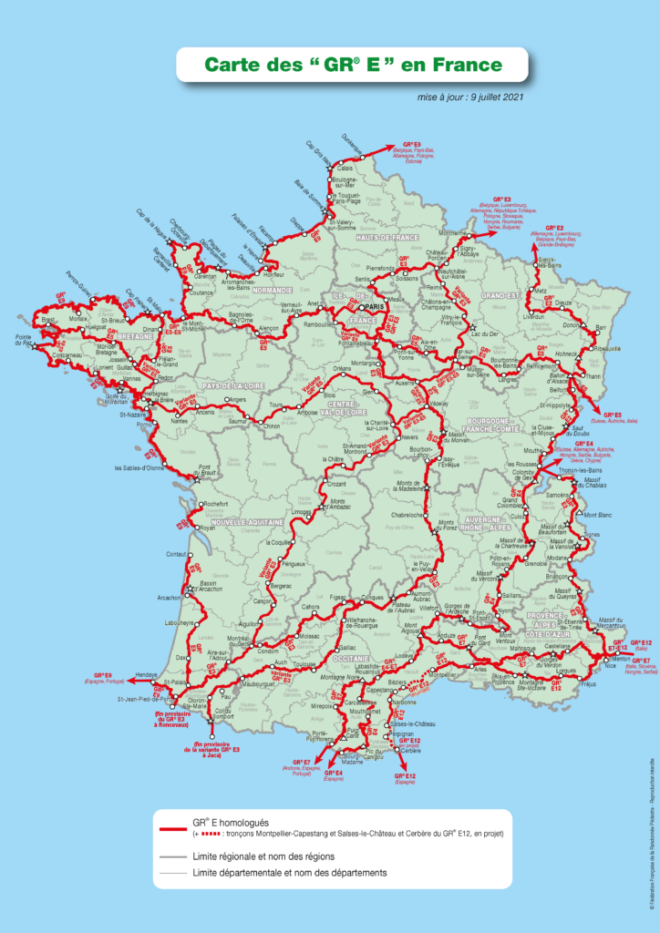
See map at the end of this page.
Practical
The division into stages is guaranteed by the regular presence of accommodation, resources and transport all along the E-path.
Gear
No specific gear required.
Links
Legal notice
Find all the GR® on mongr.fr
GR® is a trademark registered by the FFRandonnée, it designates the routes identified under the name of “GR®”, marked with white-red marks. These routes are creations of the FFRandonnée. Their unauthorized reproduction, as well as the GR® brand constitute an infringement liable to prosecution.