Route

Interest
château des Ducs de Lorraine à Sierck-les-Bains / cathédrale de Metz / vallée de la Moselle / ancien palais abbatial de Gorze / la Petite Suisse Lorraine / château Corbin à Liverdun / étangs de Lindre, du Stock et de Gondrexange / massif des Vosges (sommet du Donon ; Mont Saint-Odile ; château du Haut-Koenigsbourg ; sommets du Hohneck, du Grand Ballon et du Ballon d’Alsace) / forts du Salbert et du Lomont / gorges du Doubs (belvédère des Échelles de la Mort et saut du Doubs) / château de Joux à la Cluse-et-Mijoux / lac de saint-Point / forêts du Haut-Jura / fort des Rousses / lac Léman à Thonon-les-Bains / massif du Chablais (sommet des Cornettes de Bise) / vallée de Chamonix-Mont-Blanc / massifs du Beaufortain (lac de Roselend) / massif de la Vanoise (col de l’Iseran) / col du Montgenèvre / Cité Vauban de Briançon / massif du Queyras (fort de Château-Queyras) / col de Larche / massif du Mercantour / promenade des Anglais à Nice / rives de la Méditerranée (baie des Anges)
Starting Point
Luxembourg border at Apach
End Point
Nice (southern end of the E2 on the edge of the Mediterranean)

Which cities and towns does the E-path pass through
Sierck-les-Bains, Metz, Liverdun, Dieuze, Barr, Ribeauvillé, Thann, Belfort, Saint-Hippolyte, La Cluse-et-Mijoux, Mouthe, les Rousses, Thonon-les-Bains, Samoëns, Tignes, Modane, Briançon, Saint-Étienne-de-Tinée, Nice.
Length
1.427 km
Ground paths of the E-path, marking and responsible for marking
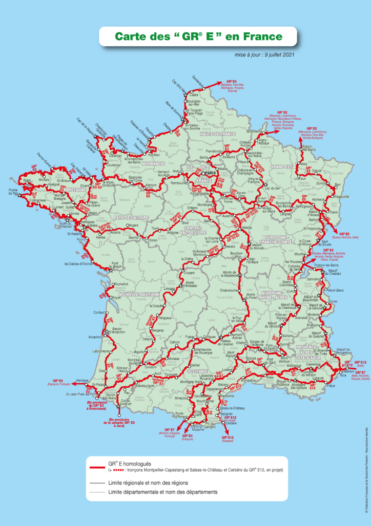
The E2 follows the entire GR®5 on French territory (from Apach to Nice)
Marking: double white-red line
Responsible for marking: FFRandonnée committees Moselle, Meurthe-et-Moselle, Territoire-de-Belfort, Haute-Saône, Doubs, Jura, Haute-Savoie, Savoie, Hautes-Alpes, Alpes-de-Haute-Provence, Alpes-Maritimes + Club Vosgien for the departments of Bas-Rhin and Haut-Rhin

Publications
Sections of the E-path on FFRandonnée topo-guides, available on the ffrandonnee.fr
 GR® 5-53 « Traversée du Massif des Vosges », ref. 502
 GR® 5-9 « La Grande Traversée du Jura », ref. 512
 GR® 5 « Du Léman à la Vanoise », ref. 504
 GR® 5-55 « La Vanoise », ref. 530
 GR® 5-56 « De la Maurienne à l’Ubaye », ref. 531
 GR® 5-52-52A « Le Mercantour », ref. 507
Maps
IGN has several maps that cover the route
Crossing other E-paths
See map at the end of the page.
Practical
The division into stages is guaranteed by the regular presence of accommodation, resources and transport all along the E-path.
Gear
No specific gear required.
Links
Legal notice
Find all the GR® on mongr.fr
GR® is a trademark registered by the FFRandonnée, it designates the routes identified under the name of “GR®”, marked with white-red marks. These routes are creations of the FFRandonnée. Their unauthorized reproduction, as well as the GR® brand constitute an infringement liable to prosecution.