
Ciglarjeva pot
Route
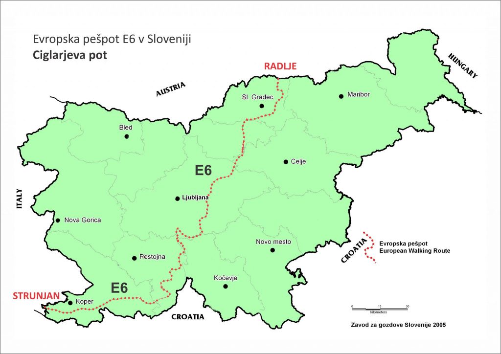
The Slovenian section of the E6 is called Ciglar’s Trail (Ciglarjeva pot) from the Drava river to the Adriatic Sea. It is named after the late Dr. Milan Ciglar, a forester who encouraged and promoted hiking along European Footpaths in Slovenia. The route is marked from the north to the south of Slovenia and climbs the highest on the Snežnik at 1796 m. It crosses Pohorje, the hills of Posavje and the individual hills of the Slovenian Dinaric world until it ends on the banks of Adriatic Sea. See route description here.

On the way you can collect stamps at 39 checkpoints http://eupoti.com/_private/Kontrolne_tocke_E_6_sep_19.pdf , print them in the diary http://eupoti.com/kontrolne_tocke_dnevniki.htm and send it to the following address: Turistična zveza Slovenije, Miklošičeva cesta 38, 1000 Ljubljana, Slovenia. You will receive a memorial badge of the trip and will be invited to the annual meeting of European travelers in Slovenia.
Starting Point
Radelj/Radlpass (border with Austria)
End Point
Strunjan (Adriatic Coast) / Sečovlje (Plovanija) (border with Croatia)
Which cities and towns does the E-path pass through
Radlje ob Dravi – Mala Kopa – Turiška vas – Mozirje – Trojane – Moravče – Jevnica – Grosuplje – Turjak (variant through Iška) – Mačkovec – Loški Potok – Snežnik – Ilirska Bistrica – Slavnik – Podgorje – Hrastovlje – Kubed – Šmarje pri Koper – Strunjan (Adriatic Coast) – Piran – Sečovlje (Plovanija – border with Croatia)
List of all places along the path
Length
350 km, 12 – 15 days easy walking
Ground path of the E-path
https://www.alltrails.com/explore/recording/evropska-pespot-tocke-sled-e-6-mar-3-3-celota-4488583
The trail connects several mountain paths and theme trails.
Responsible organisations
Planinska zveza Slovenije/Alpine Associaton of Slovenia, Dvorakova 9, 1000 Ljubljana
Tel. 00 386 1 434 56 80, fax. 00 386 1 434 56 91, www.pzs.si, info@pzs.si ,
KEUPS (Komisija za evropske pešpoti v Sloveniji), Večna pot 2, 1000 Ljubljana, http://eupoti.com/ keups.slo@gmail.com
Publications
Guide to E6 SLO, Turistična zveza Slovenije, 2003, in English http://eupoti.com/eupath/ciglar_e6_path.htm
Dario Cortese: Evropska pešpot E6, Mladinska knjiga, Založba Porezen:
1630@porezen.si GSM: 00 386 (0) 31 601 630).
Maps
Pohorje 1:50.000, Planinska zveza Slovenije, 2008.
Kamniško-savinjske Alpe 1.50.000, Planinska zveza Slovenije, 2009
Posavsko hribovje – zahodni del 1:50.000, Planinska zveza Slovenije, 2002.
Ljubljana in okolica 1:50.000, Planinska zveza Slovenije, 2003.
Snežnik 1:50.000, Planinska zveza Slovenije, 2008.
Slovenska Istra, Čičarija, Brkini in Kras 1:50.000, Planinska zveza Slovenije, 2010.
Marking system
The E6 hiking trail in Slovenia is marked by a round marker with a yellow center and red border. The symbol used to mark footpaths is also a yellow arrow.
Crossing other E-paths
E6 crosses E7 in the west/middle of Slovenia, in Mačkovec (Kraševec Milan, Selo 14, 1315 VELIKE LAŠČE, 00386 ( 0) 41 467 472), and crosses E12 in Strunjan.
Practical
Accomodation
There are different types of accommodation available: in mountain huts, tourist farms, hostels or bivouacs. In several places you can also pitch your tent or sleep in the barn by arrangement with the owners.
http://eupoti.com/eupath_e6_e7_slo/basic_data_of_e6_slo.htm
Food
Bring food for a day, as there are shops, inns and farms along the way where you can buy food or you can eat in mountain huts and inns.
http://eupoti.com/eupath_e6_e7_slo/basic_data_of_e6_slo.htm
Travel
Trains cover most of the country https://potniski.sz.si/ , as do busses https://www.ap-ljubljana.si/ . (Railway stations: Radlje ob Dravi, Jevnica, Koper, Grosuplje)
Gear
Suitable and comfortable footwear, shoes with good ankle support and a profiled, stiff sole, you should have warm spare clothes in your backpack – anorak, cap, gloves, long-sleeved T-shirt – which will be useful in case of a sudden change in the weather. Also do not forget first aid, a headlamp, matches and a candle, an astronaut foil that helps to store a lot of body heat, a mobile phone with a full battery, sunscreen and sunglasses. Do not forget the water bottle. Along the hiking trail you can get fresh drinking water from springs and wells.
Links
For additional questions along the trail, you can contact the coordinators of the European hiking trails: http://eupoti.com/_private/clani_keups_koordinatorji_26_4_20.pdf